St. Paul's Hospital - A history of the new hospital site.
I'm working on an archaeological collection that was found on the new St. Paul's Hospital property in the False Creek Flats area of Vancouver, BC - just southeast of where Main St. (Westminster Ave.) and Prior St. used to cross. I'm only providing the history of the property here, because it is fascinating and I wanted to share it with someone.
History of the False Creek Flats Property
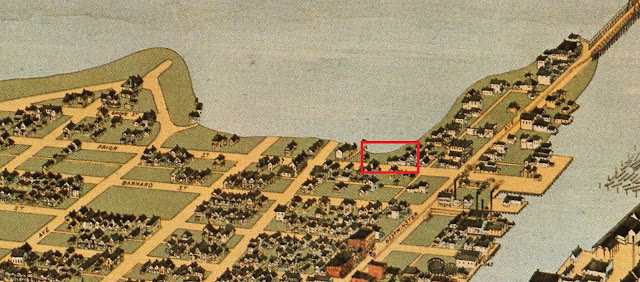
Excavations that provided the artifacts for an archaeological analysis are estimated to be from Lots 10-15 on the south side of Prior Street in Vancouver's False Creek Flats region (east of Main St., on and to the right of the number 25 in Figure 1). These equate to the addresses between 234 and 248 Prior Street between Park Lane and Gore Avenue. This 1912 Fire Insurance map clearly shows the buildings within these lots. And the original water line can be seen cutting through the property.

Panama Canal 1915
With the upcoming opening of the Panama Canal in 1915, cities all up and down the West Coast of North America prepared for much busier harbours. Vancouver was no exception. All levels of government knew they would be able to attract more people to this rapidly growing city. The natural beauty of BC would attract the tourists, the money to be made from Western Canada’s natural resources would attract business, and that in turn would continue to drive immigration. Permanent residents were already moving to the city in droves.
Planning had been going on for over a decade, but by 1914 a very large, new dock (800 ft long and 300 ft wide) was being built on the south shore of Burrard Inlet between Commercial and Salisbury Drives, the east basin of False Creek was being filled to house two new railway stations and all that implies, and a sea wall was being constructed (Vancouver Sun, April 6, 1914 p.66). After only 28 years as an incorporated city, Vancouver had been doing nothing but grow into the successful harbour the federal government had always needed: an anchor to connect the West Coast to the eastern hub of the country and protect this more vulnerable part of Canada from American interests. Millions of dollars were spent on the improvements. But it had taken a few years to get here.
The Development of False Creek Pre-1900
The first commercial venture in Vancouver was Edward Stamp’s Mill just east of Coal Harbour on Burrard Inlet. The lumber industry was huge in the early years of Vancouver (it's still one of BC's biggest industries), and logging likely first affected the east basin of False Creek (the False Creek Flats) when Jeremiah Rogers began to log its eastern slopes in the 1870s. In 1872, the first bridge over False Creek at Westminster Ave (Main Street) was built.
This 1876 map details the lots that were already laid out and claimed. The Government Reserve of Granville (pink property just right of centre) was the beginnings of the city that would develop here. Ten years later the city of Vancouver was incorporated in April 1886 just after the CPR was completed and one month before the first passenger train left Montreal for the west coast.

False Creek, when Vancouver was first being colonized, was a place for colonizers to conduct business that was tied to the water – like logging and wood processing. It also was utilized for recreational purposes, and as a dumping ground for refuse. None of these purposes would have interfered with the others at first, but as the city grew, they all came into conflict.
By 1887, the area we are interested in (Lots 10-15 on the south side of Prior Street) was starting to become populated – a few buildings are highlighted on this 1887 map, but no indication of a dump is seen. The “Waggon Bridge” is prominent, though.

You can see, in the photo below (and the map above), the wagon bridge that was built on the south end of Westminster Avenue (Main Street) – the excavation property is beyond and to the right of the large white building (hotel?) at the end of the bridge. Again, there no clear indication in this photograph of the area being used as a dump. But it would be logical for local businesses to toss their debris into the water-logged area (the depth of the water here is very shallow – most of the east basin was mud flats covered at high water, a small area directly to the east of the bridge was 1/4 to 3 ¼ m deep, presumably at low tide).

The 1889 fire insurance map below shows the same area with Westminster Avenue on the left. Gore is the street heading north in the upper right-hand corner. We see clearly here that there were two buildings in the general location we are looking at. One is a Chinese laundry, the other is a wooden building with a shed. Both are on platforms off this little inlet of mudflat. I am quite surprised that no Chinese-specific artifacts have been identified in the collection because there was a substantial Chinese presence in the area. That could have been a preservation issue, or more likely related to people digging at the site and removing the Chinese artifacts.

This panoramic view of Vancouver shows the north shore of the east end of False Creek in 1898. Again, no indication of messy dumping activity is to be seen on this pristine promotional map.
The Development of False Creek Flats After 1900
As early as 1901 there were discussions about how to best develop False Creek. By 1906, this map was produced showing proposed dredging, wharves, and a pier (Granville Island) in the main portion of False Creek. The map also shows the “Mud flats (of the eastern portion of False Creek) covered at high water granted to the City of Vancouver by order in Council 8th June, 1901” on the right side of the map.

The excavations that provided these artifacts are estimated to be from Lots 10-15 on the south side of Prior Street. These equate to the addresses between 234 and 248. The 1912 Fire Insurance map clearly shows the buildings within these lots (Figure 1), and this 1901 (1897) map shows that the platforms were built out over the flats before 1897.

The east basin of False Creek - that portion east of Main (Westminster) Street - as part of the pre-Panama development, was filled-in between 1912 and 1916 to provide more usable land. The dredging of the False Creek channel (west end) commenced April 5, 1912 (The Province, April 20, 1912 p.37), and with very public debates and arguments in the local papers, development continued until the Great Northern Railway Station was opened on June 1, 1917 (Vancouver Sun, June 2, 1917).
As World War I was raging, Vancouver was at work securing more infrastructure. The newly created land was to be used for the Great Northern Railway station, bringing beauty and passengers to this previously less-than-desirable area, and gently pulling the center of the city a little further south and east.
About four million cubic yards of fill was needed to make solid land out of the east end of False Creek. By the spring of 1914, “… about one million cubic yards of sand, rock and silt (had been) dredged from the False Creek channel by the Pacific Dredging Co.” (Vancouver Daily World May 15, 1914 p.24). The development of the western (main) portion of False Creek included creating a deep channel, 350 feet wide and 21 feet deep at low tide (Vancouver Sun April 6, 1914 p.67). This would provide deep water access to the businesses on False Creek and fill for the Flats. Some other materials used as fill came from the dredging of the Pitt River – between where it meets the Fraser River and Port Coquitlam (Vancouver Daily World August 7, 1913, p.8).
The best quality photograph I’ve been able to find of the area where the collection was found is this 1916 photo of the ground already filled and leveled on the south side of Prior and east of Park Lane. This photograph helps us date the collection to before 1916. Should any artifacts show a date absolutely after 1916, we would know there was some disturbance.

This next photo shows False Creek Flats in April, 1913 facing east from Park Lane (the road on the left of the 1916 image behind the hotel). It is the best photo showing the details of the early fill – which seems to have been through the middle of the water so as to connect park lane with the northern shore of False Creek further east.

The following photo was taken in July, 1913 from the mainland to the south (to the far right of Figure 10), and shows that the buildings on the south side of Prior were removed by that time. The building jutting into False creek near the left centre of the photo is the Vancouver Creamery – the white building on the left is the Globe Hotel with the Cunningham (Ivanhoe) behind it. You can see the same buildings as in the 1916 photo on the north side of Prior in the centre background. See also the 1912 Fire Insurance Map (Figure 1). Filling of this part of False Creek started in 1913 – for “several months” before October 23 (The Province October 23, 1913 p.22 “Canadian Northern Railway is Going Ahead with Plans for Filling-in of False Creek”). The fill began in this general area because the Great Northern Terminal needed to be started first.


Garbage Disposal in False Creek Prior to WWI
Garbage collection in Vancouver was initially done by private “Scavenger” companies or by property owners and was dumped at various spots in the city. Initially they would have been casual dumping areas, but the dumps that offended the fewer and poorer people would have been used for the longest period of time.
A “crematory” had been built at the City Yards in 1890 to help deal with some of Vancouver’s waste and dead animals and a dump developed along with it. They smelled and the crematory could no longer handle enough of the waste as the nineteen-hundreds brought thousands of new immigrants. Some popular dumping spots were along False Creek and the Flats – they also smelled, encouraged flies, and were blamed for the spread of water-borne diseases such as Typhoid (Keeling 2004:69).
In 1907 an incinerator (a Heenan Froude) was installed near the crematory. The city was getting more involved in garbage collection around this time and bought out the largest private scavenging company in the city. But the official city scavenging system was “incomplete” and private scavengers remained in business (The Province August 14, 1908 p.16). Obviously, the scavengers sold what they could, but would have hauled the excess waste to a dump.

There were several dump locations in the city, the largest being the city dump at the city yards at the south end of the Cambie Bridge (The World, July 6, 1906). False Creek Flats had its dumps, too.
Prior to filling, the False Creek Flats had shallow water over most of it at high tide, and at low tide a small portion was less than 3.25 m deep (see Figure 7). After the Great Northern Railway Company (GN) and the city agreed to the GN filling False Creek Flats in 1909, the city began to encourage dumping at the south end of Gore Avenue (Luxton 2013:16; Vancouver sun June 9, 1911 p.29). Compare the north shoreline in 1901 (Figures 7 and 13) to one from 1912 (Figure 14):

 Figure 14. Showing the north side of False Creek Flats in 1912 (City of Vancouver Archives Fire Insurance Maps detail of plates 71 and 72 342b.07 and 342b.08)
You will note that a large piece of land had been created from dumping for only 3 years at the end of Gore Avenue. That dump was a nuisance to those living in this eastern portion of Vancouver. For a time, all manner of garbage was dumped here, but “some time” before June of 1911, only ashes and earth were supposed to be allowed. Manure, however, was still being dumped and caused a great stench and possibly health risk from Typhoid (Vancouver Sun June 24, 1913 p.3; Keeling 2004:69; The Province, January 19, 1912 p.38).
It is possible that our area was used to dump materials occasionally before 1909, but after the buildings were demolished ca. 1912, the city would have encouraged the dumping of materials here to help fill it. The Gore Avenue dump may also have been pushed into the St. Paul's location as filling happened 1913-1914. I do have it on good authority that the area along the north shoreline has been previously dug by collectors, so some of the more interesting bottles are likely missing in our collection (Bill Wilson pers. comm. 2021).
As a last mention, there was also a garbage dump toward the east end of the flats – likely created when the Gore Avenue dump was filled in. This garbage was still being used in 1941 (Vancouver Sun September 17, 1941 p.17). This dump was known to the bottle collectors as the "stopper dump" due to the many internal thread stoppers that were found there (Bill Wilson pers. comm. 2021). I was fortunate enough to find this map that shows that dump in 1927.


One other thing that I just found out - After the land was filled in for the railway, the famous Hogan's Alley (an African-American neighbourhood in Vancouver) started to form less than a block away from the St. Paul's property. An indication that this land continued to be inexpensive and allocated for marginalized ethnic groups.
If you would like information on any of the references noted here, please contact me directly.

Comments
Post a Comment